PEOPLE vs EARTHQUAKE: Pre-Organisation of Safe Zones in Istanbul, Turkey
Karaveli Andrée Sonad
Presentation, English, 31 pages
Summary
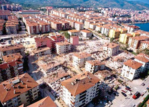
In Turkey most of the people are living in earthquake zones and we can say that they are used to it. In Turkey, most of the destroyed or damaged cities were reconstructed as they were, with their vulnerability and the same urban structure. But in 1999 two big earthquakes hit Izmit and Düzce, two cities on the coast of the Marmara Sea. The one in Izmit destroyed almost all the city and the losses were high. It was a beginning for big changes in the urbanisation procedures in cities. These earthquakes happened on the west side of an active fault line, NAF. Right after the event academics started to do a research to see the changes and current situation of the fault line. Stress accumulation maps of the fault line indicated a possible future earthquake at the end of the fault line, in the middle of the Marmara Sea, with the same intensity as that of the Izmit earthquake. This news alerted the authorities about a future disaster in Istanbul, the 12 million-inhabitant metropolitan city. Many studies have been done to understand and ameliorate the current situation of the city. All the studies pointed out to some districts with a high risk status. Zeytinburnu is one of the most vulnerable districts in Istanbul; its urban growth has been uncontrolled and illegal. The first settlements were illegal shanty houses, which have been later on legalised by law. Today the Zeytinburnu municipality conducts many projects to improve the urban quality of the district. One of the important issues, when dealing with earthquakes, is the disaster management. Earthquake Master Plan for Istanbul has created and adapted frameworks on this subject, but today most of the efforts are towards renovation and mitigation strategies. Emergency strategies are only done on paper: a map has been made with plans of evacuation arteries, and location of the responsible organisation, primary community evacuation areas and tent villages. But if the tent villages’ layout has not been designed, will the villages be efficiently organised, especially as they are needed during the first hours after an earthquake
Topic
Earthquake resistant | Urban planning